This is a satellite image of the fabulous Namib Desert as seen through Google Maps. You have seen my ground level shots as I climbed dune 7 but this really shows how much sand has pooled here.
Google Maps has recently expanded its online offering to include all views once available only via the download’able Google Earth. Go check out the major cities of the world, I have! 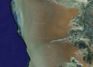

Like this:
Like Loading...
Michael Paskevicius
Share post:
This is a satellite image of the fabulous Namib Desert as seen through Google Maps. You have seen my ground level shots as I climbed dune 7 but this really shows how much sand has pooled here.
Google Maps has recently expanded its online offering to include all views once available only via the download’able Google Earth. Go check out the major cities of the world, I have!

Share this:
Like this:
Gobabeb 2006
Gobabeb 2006
Share this:
Like this:
Continue Reading
The Desert Brings Peace
Tomorrow I will head back to the Gobabeb Research Facility for a conference on renewable energy sources organized by the Polytechnic of Namibia and the Gerter Institute of Namibia. I. read more…
Share this:
Like this:
Continue Reading
Gobabeb Research Centre
Journey to the Gobabeb Research Centre I took Friday off from work so that I could travel with colleagues to the Gobabeb Research Centre in the middle of the Namib-Naucluft.. read more…
Share this:
Like this:
Continue Reading